
A GIS consultant typically costs $20 to $30 per hour on global freelance marketplaces and roughly $80 to $136 per hour on US federal contracts, with independent North American consultants in between. The three sample projects below cost $1,300 to $13,200. Data condition, scope clarity and revision rounds move a quote more than the hourly rate does.
This guide covers what published wage and contract data say about GIS consulting rates, task-level hour estimates for three real-world project types, and how fixed-fee, hourly and retainer pricing compare.
How much does a GIS consultant cost per hour?
GIS consultant cost depends on which market you are buying from. Four public data sources give a useful frame. They measure different things, so read the labels.
| Source | What it measures | Figure |
|---|---|---|
| Upwork | Median freelance rate for GIS developers on the platform (global talent pool) | $20 to $30 per hour |
| GSA CALC+ ceiling rates, "GIS Technician" categories | Maximum hourly price on US federal schedule contracts (31 categories) | Median $80.35 |
| GSA CALC+ ceiling rates, "GIS Analyst" categories | Same, 38 categories titled exactly GIS Analyst | Median $98.69 |
| GSA CALC+ ceiling rates, GIS developer, programmer and engineer titles | Same, 162 categories | Median $136.07 |
| BLS OEWS, Cartographers and Photogrammetrists | US employee wage, not a billing rate, May 2025 | Median $39.13 per hour |
| BLS OEWS, Geographers | US employee wage, May 2025 | Median $49.06 per hour |
| Job Bank Canada, NOC 22214 | Canadian employee wage for GIS and geomatics technicians, updated November 2025 | Median CA$38.10 per hour |
The GSA figures come from the CALC+ ceiling-rate dataset, which I queried on 18 October 2026 for every labor category with "GIS" in the title. There were 1,131 of them. Across all of them the median ceiling rate was $110.90, the 25th percentile $87.81 and the 75th percentile $142.48.
What the federal contract numbers actually mean
GSA describes these as ceiling prices that "represent max vendor pricing" and notes that discounts often happen when task orders are awarded. They are fully loaded rates from established firms, including overhead, insurance and profit. They are a reasonable upper reference for a US public-sector buyer, not a quote anyone is obliged to accept.
What the wage numbers actually mean
BLS and Job Bank report what employers pay staff, before benefits and overhead. A consultant billing the BLS median wage would be losing money. The useful comparison is the spread: the 90th percentile hourly wage for US cartographers and photogrammetrists is $61.03, and for geographers $65.70. Senior specialists earn well above the median, and their billing rates follow.
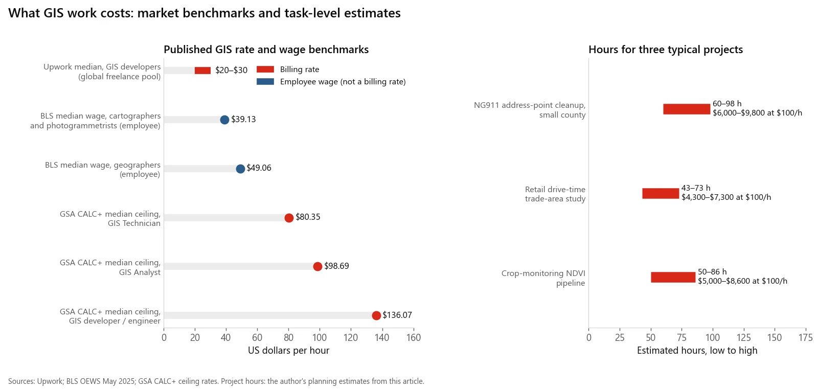
Published rate and wage benchmarks, and the hour ranges for the three sample projects below. Wages are employee pay, not billing rates.
Why does a GIS consultant charge more than a GIS analyst earns?
Compare the GSA median ceiling rate for GIS Analyst categories ($98.69) with the BLS median wage for geographers ($49.06) and cartographers ($39.13). The billing rate is roughly 2 to 2.5 times the wage. That gap pays for things an employer would otherwise cover:
- Unbilled time. Proposals, scoping calls, invoicing and learning new tools are not billable, so every billed hour carries some unbilled ones.
- Software and data. ArcGIS licenses, cloud compute, routing services and storage come out of the consultant's pocket.
- Benefits and taxes. Health coverage, retirement savings and self-employment taxes are not included in a wage figure.
- Gaps between contracts. Rates have to cover the weeks with no client work.
- Liability. Professional liability insurance, which many public agencies require.
When you compare a consultant's rate with a staff salary, compare it with the fully loaded cost of the employee, not the hourly wage.
How many hours do typical GIS projects take?
Hourly rates mean little without hours. Below are three sample projects, one from each of the segments I work in, broken into task-level estimates. The hours are my planning estimates for a competent solo consultant, not figures from a survey. They assume one round of revisions and reasonably cooperative data owners.
Cost columns use three illustrative rates drawn from the table above: $30 (top of Upwork's median band), $100 (near the GSA GIS Analyst median) and $135 (near the GSA GIS developer median).
Sample 1: NG911 address-point cleanup for a small county
Scope: about 12,000 address points and 1,500 road centerline segments, brought into alignment with the NENA NG9-1-1 GIS data model, with an exception report for county staff. Background on why this matters is in NG911 GIS data readiness.
| Task | Hours (low to high) |
|---|---|
| Kickoff, data inventory, mapping existing fields to the NENA schema | 6 to 10 |
| Data acquisition and cleanup: street name parsing, pre-directionals and street types, geometry repair | 18 to 28 |
| Analysis: automated checks for duplicates, points outside the boundary, address range and parity conflicts with centerlines | 10 to 16 |
| Exception resolution with county staff, using imagery and assessor records | 12 to 20 |
| Map and report production | 6 to 10 |
| Internal QA | 4 to 6 |
| Revisions (one round) | 4 to 8 |
| Total | 60 to 98 |
| Rate | Estimated cost |
|---|---|
| $30/hr | $1,800 to $2,940 |
| $100/hr | $6,000 to $9,800 |
| $135/hr | $8,100 to $13,230 |
Cleanup plus exception resolution is 30 to 48 of the 60 to 98 hours, about half the job. That is why the condition of the source data swings this quote more than anything else. A county whose address points were already standardized for its CAD system can come in under the low estimate. Automated geometry and CRS checks, the kind GeoLint runs, shrink the QA line but not the human review of exceptions.
Sample 2: Retail drive-time trade-area study
Scope: 25 candidate sites in one metro area, 5, 10 and 15 minute drive-time trade areas, demographics apportioned from US Census American Community Survey block groups or Statistics Canada census dissemination areas, competitor overlap, and a ranked shortlist. This is the core of most retail site selection GIS work.
| Task | Hours (low to high) |
|---|---|
| Criteria workshop and agreeing scoring weights with the client | 3 to 5 |
| Data acquisition and cleanup: geocoding sites and competitors, census tables, road network | 8 to 14 |
| Analysis: drive-time polygons, demographic apportionment, competitor and candidate overlap, scoring | 14 to 24 |
| Map and report production: one-page site cards and ranking table | 10 to 16 |
| QA: travel-time spot checks against a routing engine such as OSRM, apportionment totals | 4 to 6 |
| Revisions (one round) | 4 to 8 |
| Total | 43 to 73 |
| Rate | Estimated cost |
|---|---|
| $30/hr | $1,290 to $2,190 |
| $100/hr | $4,300 to $7,300 |
| $135/hr | $5,805 to $9,855 |
The scoring workshop looks small but decides whether the study is useful. On the Taleemabad franchise rollout, where I built location scoring that ranked catchments by population, competition and accessibility, agreeing what "a good catchment" meant took more back-and-forth than running the numbers. Budget for it. Adding sites is cheap once the pipeline exists: sites 26 to 50 cost far less than sites 1 to 25.
Sample 3: Crop-monitoring NDVI pipeline
Scope: 40 field boundaries in one region, Sentinel-2 imagery from the free Copernicus Data Space Ecosystem, cloud-masked composites every two weeks through one growing season, NDVI and NDRE per field, anomaly flags and a CSV plus map output.
| Task | Hours (low to high) |
|---|---|
| Requirements, ingesting and cleaning field boundaries | 6 to 12 |
| Data acquisition: imagery access, cloud masking, compositing, mosaicking | 12 to 20 |
| Analysis: vegetation indices, per-field zonal statistics, anomaly flags | 10 to 16 |
| Outputs: maps, CSV, scheduled report or simple dashboard | 10 to 18 |
| QA: cloud mask checks, tile seams, comparison against known field events | 6 to 10 |
| Revisions, documentation and handover | 6 to 10 |
| Total | 50 to 86 |
| Rate | Estimated cost |
|---|---|
| $30/hr | $1,500 to $2,580 |
| $100/hr | $5,000 to $8,600 |
| $135/hr | $6,750 to $11,610 |
The imagery is free; the engineering is not. Fields that straddle two Sentinel-2 tiles or UTM zones need mosaicking and tile levelling, which is exactly the problem I built sen2auto to handle. After the build, each season's runs are a small recurring cost, which is why this project type suits a retainer.
Fixed fee, hourly or retainer: which GIS pricing model is best?
| Model | How it works | Best for | Risk sits with | Watch out for |
|---|---|---|---|---|
| Hourly (time and materials) | Pay for hours worked at an agreed rate | Discovery work, messy or unknown data, small jobs | Buyer | Open-ended bills. Ask for a not-to-exceed cap and weekly hour reports |
| Hourly with not-to-exceed cap | Hourly, but the total cannot pass a ceiling without written approval | Public agencies, first projects with a new vendor | Shared | Caps set too low lead to rushed QA near the limit |
| Fixed fee | One price for a defined set of deliverables | Repeatable work with clean, known inputs | Consultant | Expect a buffer for unknowns in the price. Scope changes become change orders |
| Per unit | Price per address point, site, field or map sheet | Large, uniform batches | Shared | Units with very different difficulty get averaged |
| Retainer | A monthly block of hours or a standing service | Ongoing monitoring, map maintenance, on-call support | Shared | Unused hours. Agree whether they roll over |
Public bodies often combine these. The Central Vermont Regional Planning Commission's GIS cost of services policy, effective February 2017, gives each member town 12 free hours a year, bills further work at cost, requires a written estimate and contract for major projects, and charged for-profit businesses $90 per hour at the time.
A simple rule for choosing
- If you cannot describe the deliverable in one paragraph, start with a small hourly discovery phase. Then fix-price the rest.
- If you have done the project before and the data is known, a fixed fee is fair to both sides.
- If the work repeats on a schedule, use a retainer sized from the first few months of actual hours.
What drives a GIS quote up or down?
In rough order of impact:
- Data condition. Inconsistent street names, mixed coordinate systems, duplicated features and missing attributes are where hours go. Send a sample of the real data before asking for a quote.
- Scope clarity. "Make us a map of service gaps" and "deliver a GeoPackage of 15-minute drive-time polygons for these 25 addresses, plus a 10-page PDF" will get very different quotes.
- Revision rounds. In Samples 1 and 2, one round of revisions is 4 to 8 hours, about 7 to 11 percent of the total. Name the number of rounds in the contract.
- Data purchases. Census and Statistics Canada tables, OpenStreetMap and Sentinel-2 are free. Commercial business listings, parcel data and high-resolution imagery are not, and they are usually passed through at cost.
- Software requirements. Requiring delivery in a specific Esri version, or as a hosted ArcGIS Online app, can add licensing cost. Open formats such as GeoPackage cost nothing extra.
- Procurement overhead. Insurance certificates, vendor registration, security questionnaires and formal progress reports take real time on public-sector work.
- Timeline. Rush delivery means displacing other clients, and is often priced at a premium.
How do US and Canadian GIS quotes differ?
- Currency. Job Bank wages are in Canadian dollars. Confirm the currency on every quote, especially when comparing a Canadian consultant with a US firm.
- Sales tax. The Canada Revenue Agency requires GST/HST registration once gross taxable sales pass $30,000 over four consecutive calendar quarters. Registered consultants add it to the invoice.
- Data sources. US demographic work uses the American Community Survey and TIGER geography; Canadian work uses Statistics Canada census data and dissemination areas. The pipeline is the same, but the geography crosswalks and variable names differ, so a consultant new to one country will spend extra hours.
- Units and coordinate systems. Trade areas in miles versus kilometres is trivial. Datums are not: US data is usually on a NAD83 realization, while Canadian provinces have adopted NAD83(CSRS) at specific epochs. Specify it up front; the hiring guide has the wording.
How can you lower the cost of a GIS project without cutting quality?
- Do the data gathering yourself. Exporting layers, pulling records and finding the person who knows why a field exists are tasks your staff can do cheaply.
- Fix the deliverable list before the quote. File formats, map count, report length and coordinate system. See the statement-of-work template in how to hire a GIS contractor.
- Pay for a short pilot. One township, five sites or ten fields. It reveals the data problems before they become a change order.
- Accept open formats. GeoPackage and CSV avoid license-dependent deliverables.
- Consolidate review. One reviewer with authority, one round of consolidated comments.
When hourly benchmarks are the wrong way to judge a quote
- Rates hide hours. A $35 per hour bid that takes 200 hours costs more than a $120 per hour bid that takes 50. Compare totals against the same deliverables.
- The marketplace median is global. Upwork's figure mixes freelancers from every country and skill level. It says little about who will understand NENA attribute rules, US Census geography or Canadian datum epochs.
- Federal ceilings are ceilings. GSA rates are maximums for large firms, not a market price for a small-town project.
- Wage data is not billing data. BLS and Job Bank figures describe staff pay, and Job Bank's occupation group covers technicians, not senior analysts.
- My hour estimates are estimates. They come from planning similar work, not from a study of completed projects. A county with badly broken address data can double Sample 1; a retailer with a clean site list can halve Sample 2.
If you want a task-level estimate for your own project, or want it done, email me at mahad.imran29@gmail.com. Send a sample of the data and a paragraph on what you need, and I will reply with hours, a price and the assumptions behind them.