
Mahad Imran

Maps, spatial data, and analysis.

I'm a geospatial data scientist and a GIS consultant. I work on location intelligence and spatial optimization, which in plain terms means working out where things should go, like which neighbourhoods a new store should open in, or where a city should put its fire stations so help arrives in time.

I also use LLMs to automate the slow, repetitive parts of GIS, like cleaning messy address data or rerunning the same analysis for a new city.

Before GIS, I spent five years building startups in education and coaching 300+ people into jobs. More on that here

Below is my published research, then a mix of client work and hobby projects, plus write-ups of analyses I've found interesting.

New paperSOCA, a conversational agent for facility location problems, is out in ISPRS IJGI
Sketch portrait of Mahad Imran

Peer-reviewedOpen accessISPRS Int. J. Geo-Inf. 2026, 15(11), 494

SOCA: A Conversational Agent for Facility Location Problems
Seonga Cho† & Mahad Imran†† Equal contribution. School of Digital Humanities and Computational Social Sciences, KAIST, Daejeon, Republic of Korea

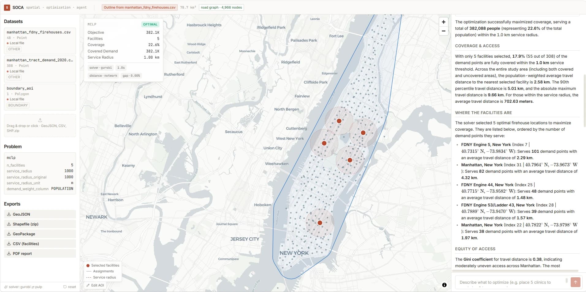
The SOCA web app: datasets and the MCLP problem on the left, a map of Manhattan with five selected firehouses and their 1 km service radii in the middle, and the agent's written explanation of coverage, facility locations and equity on the right.
SOCA solving a Manhattan firehouse MCLP: five stations within 1 km cover 382,088 residents (22.6%). The agent explains coverage, where each facility sits and how evenly access is shared. SOCA web interface.

Facility location models decide where hospitals, fire stations and warehouses go, and who ends up well served. Using them still takes two skills most planners don't have time for: writing optimization models and assembling the spatial data they need.

SOCA lets you describe a siting problem in plain English. The language model only picks the formulation and pulls out its parameters through schema-checked function calls. Everything geometric, from fetching boundaries, sites, population and road networks to solving the exact model, runs in deterministic tools, and nothing is solved until you confirm the specification.

4
classic models solved exactly: P-Median, P-Center, MCLP and LSCP
Exact
match with the spopt reference optima on all four
7
study areas fed by the open-data pipeline, from New York to Gilgit
93.4%
of Manhattan residents within 2 km of 10 chosen firehouses
Published 30 October 2026 in the ISPRS International Journal of Geo-Information special issue LLM4GIS: Large Language Models for GIS. DOI 10.3390/ijgi15110494

  • Spatial optimization
  • Spatial decision support systems
  • Conversational AI
  • Location decision intelligence
  • Large language models
  • Facility location problems

Franchise Location Analysis: Taleemabad

Built GIS-based location scoring to guide a nationwide school franchise rollout, ranking catchments by population, competition, and accessibility.

  • QGIS
  • Census data
  • OSM

Practical guides and spatial analyses: NG911 data, site selection, coverage modelling and crop monitoring.

All articles →

Let's talk.

Best way to reach me is email. I respond to most things.