To hire a GIS contractor, first write down the decision the work supports and the exact datasets you want back. Then issue a statement of work that fixes the coordinate system, file formats, metadata, data dictionary, acceptance tests and data ownership. Interview vendors on how they handle bad data, and pay for a small pilot first.
This guide covers when a small city or county should outsource GIS services, a scoping checklist, a copyable SOW template, interview questions that expose weak vendors, and how to accept the work.
Should a small city or county outsource GIS or hire staff?
There are four realistic models, not two. The right one depends on how often you need GIS, not on how much you like maps.
| Model | What it looks like | Fits when | Typical weakness |
|---|---|---|---|
| In-house staff | One or more GIS employees own the data and the tools | Weekly operational edits (addressing, permits, utilities), many departments using GIS | One-person departments are fragile; vacancies stall everything |
| Contractor | A consultant or firm does defined projects | Migrations, cleanups, analyses, web apps, one-off studies | No one inside owns the data after the contractor leaves |
| Hybrid | A trained staff member owns the data; a contractor handles heavy or specialist work | Most small cities and counties with NG911 obligations | Needs a clear split of responsibilities in writing |
| Shared service | A county, regional commission or larger neighbour provides GIS | Very small towns and townships | You queue behind other members' priorities |
What this looks like in real municipalities
- The software is not the program. Chamblee, Georgia, a city of about 28,000, had GIS software but no GIS services. Planners and economic developers tried to run it and, per the city manager quoted in GCN's August/September 2017 issue, had "nothing to show for it" after two years. The city then hired an outside firm for managed IT and GIS.
- A larger neighbour can be the contractor. Yountville, California, about 3,000 people, lacked the staff and budget to start its own GIS program. According to ICMA, it contracted with the GIS program of Rancho Cucamonga, a city of about 175,000, after finding consultants it had spoken with did not understand its processes.
- Upper-tier governments often carry small ones. In Ontario, Addington Highlands has no GIS staff and relies on Lennox & Addington County. In June 2024 its council agreed to help write a county GIS strategic plan to sort out who does what between the county and lower-tier municipalities, as Frontenac News reported.
- Regional commissions price for small members. The Central Vermont Regional Planning Commission's 2017 GIS cost policy gives each member municipality 12 hours of free GIS help per fiscal year and bills larger work at cost under a written scope and contract.
- Staff positions do go unfilled. Columbia County, Georgia's technology director told GovTech in 2023 that its IT, GIS and broadband departments all had vacancies at the same time.
A quick cost check for in-house versus contractor
The May 2025 BLS median wage for US cartographers and photogrammetrists is $39.13 an hour, which is about $81,400 a year at 2,080 hours before benefits, software and training. In Canada, the Job Bank median for GIS and geomatics technicians is CA$38.10 an hour. If your real GIS workload is a few projects a year, a contractor billing a few hundred hours costs much less. If it is a steady stream of edits across departments, staff win. The GIS consultant cost guide has task-level hour estimates for typical projects.
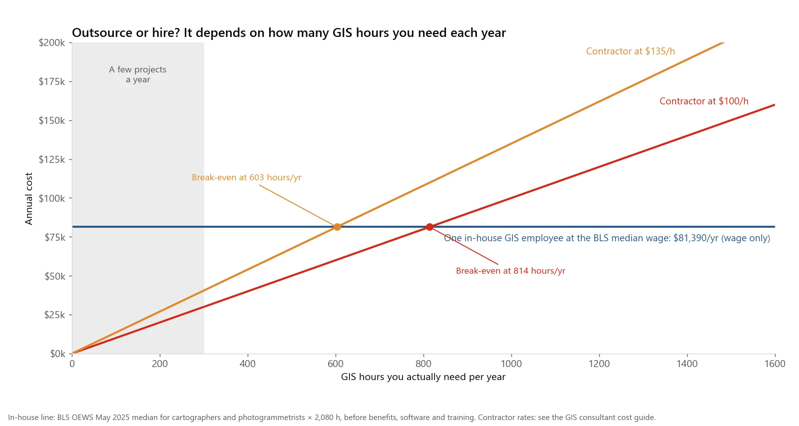
Break-even between one in-house GIS employee (wage only) and a contractor. Below a few hundred hours a year, contracting is far cheaper.
How do you scope a GIS project before you hire a GIS contractor?
Most bad GIS projects fail at scoping, not at analysis. Work through this list before you write an RFP or send an email.
- Name the decision. "Choose three sites for a new store" or "pass the state NG911 GIS submission" is a scope. "Improve our GIS" is not.
- List the inputs and who owns them. Address points, centerlines, parcels, customer lists, field boundaries. Note the format, the coordinate system if known, and who can answer questions about each.
- Send a real sample. A few hundred records of the actual data. Contractors quote very differently once they see the street names.
- Define the area. A boundary file, not a description.
- Define every deliverable. Datasets, maps, reports, apps and code, each with a format.
- Write the acceptance test. How you will decide the work is done, in numbers.
- Decide what happens after delivery. Who maintains the data, and whether you need training or documentation.
- Set a budget range and a date. Saying a range gets better proposals than hiding it.
- Check standards that apply. For 911 data, the NENA NG9-1-1 GIS data model and any state or provincial submission rules. See NG911 GIS data readiness.
What should a GIS statement of work include?
The template below is written to be copied and filled in. Square brackets are placeholders. It is a practical starting point, not legal advice; have your procurement office or lawyer review the ownership and liability clauses.
STATEMENT OF WORK: [Project name]

1. PURPOSE
   This work supports the following decision or obligation: [one sentence].

2. AREA AND INPUTS
   2.1 Area of interest: [boundary file name], supplied by Client.
   2.2 Client supplies: [list datasets, format, approximate record counts].
   2.3 Client contact for data questions: [name, role], response within
       [3] business days.

3. TASKS
   3.1 [Task, e.g. standardize address point attributes to NENA schema]
   3.2 [Task]
   3.3 Internal quality control before each delivery.

4. DELIVERABLES
   4.1 Datasets
       | Name | Geometry | Format | Approx. features |
       | [address_points] | Point | GeoPackage | [12,000] |

   4.2 Coordinate reference system
       - Horizontal: [EPSG code and name], datum realization [e.g. NAD83(2011)
         or NAD83(CSRS)], epoch [e.g. 2010.0] where applicable.
       - Vertical (if any): [datum and units].
       - Linear units: [US survey feet / metres].
       - No dataset is delivered in an undefined or "unknown" CRS.

   4.3 File formats
       - Primary: OGC GeoPackage (.gpkg), one file, one layer per dataset.
       - Secondary: [Esri file geodatabase, ArcGIS Pro version X] if required.
       - Shapefile only on request, with a field-name crosswalk.
       - Tabular outputs: CSV, UTF-8.
       - Maps: PDF at [size], plus the project file used to make them.

   4.4 Metadata
       - One metadata record per dataset following [FGDC CSDGM / ISO 19115],
         including source, processing steps, date, CRS and contact.

   4.5 Data dictionary
       - For every field: name, alias, type, length, allowed values or
         domain, whether nulls are allowed, source, plain-language meaning.

   4.6 Code and methods
       - Scripts or models used to produce the results, with a README
         explaining how to rerun them.
       - A methods note of [2-5] pages describing assumptions and limits.

5. ACCEPTANCE CRITERIA
   5.1 Zero invalid geometries (self-intersections, null shapes).
   5.2 100% of features carry all fields marked required in the dictionary.
   5.3 All datasets in the CRS specified in 4.2.
   5.4 [Project-specific test, e.g. >= 98% of address points match a
       centerline range with the same street name and correct parity].
   5.5 Client reviews each delivery within [10] business days and returns
       one consolidated list of defects. Contractor fixes defects that
       fail 5.1-5.4 at no cost.

6. OWNERSHIP AND LICENSING
   6.1 On payment, Contractor assigns to Client all copyright and other
       rights in the deliverables created under this SOW. This assignment
       is in writing and signed by both parties.
   6.2 Contractor keeps ownership of pre-existing tools and code, and grants
       Client a perpetual, royalty-free license to use, modify and share
       any of them included in the deliverables.
   6.3 Third-party data: Contractor lists every third-party source and its
       license (for example, OpenStreetMap under ODbL) and flags any
       attribution or share-alike obligations.
   6.4 Contractor does not reuse Client data for other clients and deletes
       working copies within [30] days of final acceptance, on request.

7. SCHEDULE AND MILESTONES
   - Kickoff: [date]
   - Pilot delivery on [sub-area]: [date]
   - Draft delivery: [date]
   - Final delivery: [date]

8. PRICE AND PAYMENT
   - Pricing model: [fixed fee / hourly with not-to-exceed of $X / retainer].
   - Payment tied to accepted milestones: [e.g. 20% pilot, 40% draft,
     40% final].
   - Work outside this SOW requires a written change order with hours and
     cost before it starts.

9. ASSUMPTIONS AND EXCLUSIONS
   - [e.g. Field verification is excluded.]
   - [e.g. Client provides imagery access.]
Why each clause is there
- CRS with realization and epoch. "NAD83" alone is ambiguous. The US National Geodetic Survey says NAD 83 stays official until its modernized reference frames are adopted, and Canadian provinces have adopted NAD83(CSRS) at different epochs, for example 2010 in Ontario and Alberta and 1997 in Quebec and Saskatchewan. Writing the EPSG code and realization removes the guesswork.
- GeoPackage first. GeoPackage is an open OGC standard that any major GIS reads. Esri's own shapefile documentation lists the limits that make shapefiles a poor primary deliverable: field names of at most 10 characters, text fields capped at 254 characters, and date fields that cannot store a time.
- Metadata and a data dictionary. These are what let your next contractor, or your own staff, use the data without calling the last one. The FGDC metadata page covers both the FGDC and ISO standards.
- A written assignment. Under 17 U.S.C. § 101, a commissioned work is a "work made for hire" only if it falls in one of nine categories, such as a compilation or an atlas, and both parties sign a written instrument saying so. Whether a given dataset qualifies is debatable, so an explicit assignment is cleaner. Canada's Copyright Act, section 13, makes the author the first owner and says an assignment is not valid unless it is in writing and signed by the owner.
- Third-party licenses. OpenStreetMap's license requires attribution and says that if you alter or build on the data you may distribute the result only under the same license. That matters if you plan to publish or sell a derived layer.
- A pilot milestone. It surfaces data problems while they are cheap to fix.
Deliverable formats compared
| Format | Open standard | Many layers in one file | Long field names | Date with time | Best use |
|---|---|---|---|---|---|
| GeoPackage | Yes (OGC) | Yes | Yes | Yes | Primary deliverable |
| Esri file geodatabase | No | Yes | Yes | Yes | Teams working in ArcGIS |
| Shapefile | Published spec, multi-file | No | No (10 characters) | No | Legacy systems only |
| GeoJSON | Yes (IETF RFC 7946) | No | Yes | As text | Web maps, small datasets |
| CSV with coordinates | Yes | No | Yes | As text | Tables and point lists |
What questions expose a weak GIS contractor?
Ask these in the interview. The answers tell you more than a portfolio.
| Question | A strong answer | A red flag |
|---|---|---|
| "Here is a sample of our data. What problems do you see?" | Names specific issues: mixed CRS, duplicate addresses, inconsistent street types, invalid geometry | "Looks fine" without opening it |
| "How will you know the output is correct?" | Describes automated checks plus a manual sample, with numbers | "We review everything carefully" |
| "Which coordinate system will you deliver in, and why?" | Asks what your other systems use, names an EPSG code and datum realization | "WGS84" for everything, or "whatever the data is in" |
| "What happens when the data does not match the standard?" | Logs exceptions and returns a list for your decision, does not silently delete records | "We clean it up," with no record of what changed |
| "Can we rerun this without you?" | Hands over scripts or models with a README | Process lives only in their head or in manual clicks |
| "Who owns the deliverables and any tools you use?" | Clear split between assigned deliverables and licensed pre-existing tools | Reluctance to put ownership in writing |
| "Tell me about a project where the data was worse than expected." | A specific story with what they changed in scope or price | No examples, or blames the client |
| "Who exactly will do the work?" | Names the person and their role | A senior name in the proposal, unnamed juniors doing the work |
For NG911 work, add one more: ask them to walk through the checks in NG911 centerline and address QA checks and say which ones they automate. Vague answers about "NENA compliance" without mentioning address ranges, parity or road segment connectivity are a warning sign.
What are the red flags in a GIS proposal?
- A price with no task breakdown. You cannot tell what was assumed.
- No mention of your data. A generic proposal written before looking at the inputs.
- Deliverables described as software screenshots. "An ArcGIS dashboard" is not a dataset spec.
- No acceptance criteria, or "to client satisfaction" only. That invites endless revisions or an early declaration of done.
- Proprietary lock-in. Deliverables only usable inside the vendor's hosted platform, with no export.
- Unlimited revisions at a fixed price. Either the price is padded or quality will drop on later rounds.
- Silence on third-party data. Business listings, imagery or parcel data with license terms that do not allow your intended use.
- No plan for after delivery. No documentation, training or handover.
How should you accept GIS deliverables?
Run three layers of checks before you sign off.
Automated checks
Validate geometry, CRS and required fields with a script or tool. Open-source tools such as GeoLint, which I wrote, check for invalid geometries and CRS mismatches in batches. Most desktop GIS software has equivalent validation tools. These checks map directly to acceptance criteria 5.1 to 5.3 in the template.
Sampled manual review
Pick 30 to 50 features at random and compare them with imagery or source records. Pick another 10 from the places you know are hard, such as a new subdivision or a road that changed names.
Fitness for use
Load the data into the system that will use it, whether that is a CAD system, a web map or a reporting tool. Many problems only appear at this step, such as a field type the target system rejects.
When outsourcing GIS is the wrong approach
- When nobody inside will own the data. A contractor can build a clean dataset in a month, and it can decay within a year if no one maintains it. Chamblee's two years of unused software is the mirror image: tools without capacity.
- When edits are daily and operational. New addresses, permit locations and utility changes need someone close to the work. Contract the setup and the audits, not the daily edits.
- When a shared service already exists. If your county or regional commission offers GIS help at cost, start there.
- When the data is too sensitive to leave your network. Some law enforcement, health or critical-infrastructure data may not be allowed off agency systems. Ask your security officer before scoping.
- When the real need is software, not GIS. A permitting system or asset-management platform with a map is a software procurement, with different contracts and support needs.
If you need a GIS project scoped or done, or want a second opinion on a statement of work, email me at mahad.imran29@gmail.com.