
NG911 GIS data readiness means your road centerlines, site/structure address points, PSAP, emergency service and provisioning boundaries follow the NENA NG9-1-1 GIS Data Model, load cleanly into WGS84, carry every required attribute, have no gaps or overlaps, and match your legacy MSAG and ALI records at 98% or better.
This guide covers what NG911 GIS data readiness requires, which standards apply in the US and Canada, a layer-by-layer checklist you can work through, how to measure MSAG/ALI synchronization, and a 30-point self-score rubric.
What does NG911 GIS data readiness actually mean?
In Enhanced 911 (E9-1-1), calls are routed by tables. The Master Street Address Guide (MSAG) lists valid street names and address ranges per community, the ALI database links phone numbers to addresses, and a selective router sends each call to a PSAP based on an Emergency Service Number (ESN). Your county GIS was useful for dispatch maps, but no call depended on it.
In NG9-1-1 that changes. The NENA Standard for NG9-1-1 GIS Data Model (NENA-STA-006.2a-2022) describes GIS layers that feed two core services directly:
- ECRF (Emergency Call Routing Function): takes a caller's location and returns the PSAP or responder agency whose boundary contains it.
- LVF (Location Validation Function): checks that a civic address is real and routable before an emergency happens.
So readiness is a data-quality question with a routing consequence. A gap between two PSAP polygons is a place where the ECRF has no answer. An address range that overlaps another segment with the same street name is an address the LVF can place in two locations. Montana's September 2024 readiness report names the two indicators most states watch: the MSAG synchronization rate and a gap-free statewide PSAP boundary layer. At that point only 4 of Montana's 53 PSAPs were passing MSAG validation and 7 had aggregated boundaries, which shows how much work sits between "we have GIS" and "our GIS can route calls".
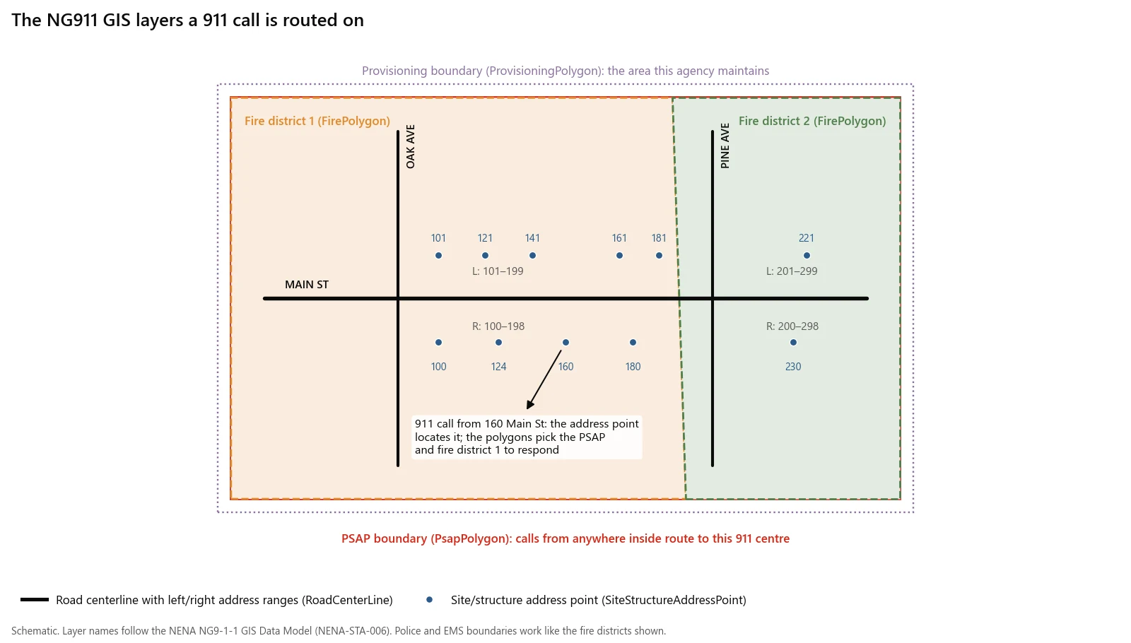
How the layers work together on one call. The address point locates the caller; the boundary polygons decide which PSAP answers and which agencies respond.
Which NG911 GIS standards apply in the US and Canada?
Both countries build on the same NENA GIS Data Model. The differences are in the civic address standard, the regulator and the timeline.
| United States | Canada | |
|---|---|---|
| GIS data model | NENA-STA-006.2a-2022 (ANSI approved 23 September 2022) is what most state schemas reference today. NENA-STA-006.3-2026, approved 11 March 2026, is the current edition. | Same NENA model. Esri Canada notes that version 3 was revised to address Canadian concerns and support geospatial routing in Canada. |
| Civic address format | CLDXF-US, NENA-STA-004.2-2024 | CLDXF-CA, NENA-STA-029.1-2025 |
| Regulator's role | The FCC's 2024 NG911 order (effective 25 November 2024) obliges originating service providers to deliver 911 traffic in IP format within 6 or 12 months of a valid request from a 911 authority. It does not set GIS data rules. | The CRTC set 31 March 2027 as the NG9-1-1 transition deadline and declined to move it when Quebecor and Rogers asked. Telecom Decision 2025-64 asked the industry working group to study how to implement a new GIS data model. |
| Who actually sets your GIS requirements | Your state 911 board or office and your NGCS provider, usually NENA plus state-specific fields. | Your provincial or territorial 9-1-1 authority and NG9-1-1 service provider, within the CRTC framework. |
| Coordinate system for submission | WGS84, EPSG:4326 for 2D and EPSG:4979 for 3D | Same |
| Address hierarchy | A1 = state, A2 = county, A3 = incorporated municipality | A1 = province or territory. In version 3 the A2 field on address points is conditional and follows CLDXF-CA rules: required in New Brunswick (county), not in Manitoba. |
Which version of the data model should you build to?
Build to whatever your NGCS or spatial interface provider ingests, and ask them in writing. Many state schemas and validation tools still target 006.2a. Version 3 changes some structure: according to Esri Canada it removes the separate Street Name Alias table (the authoritative name stays in the street name field), adds a SiteStructureAddressPolygon layer and splits distance markers from location markers. The core field names used in this checklist, such as FromAddr_L, Parity_L, St_Name and Add_Number, are the 006.2a names.
Note that you do not have to run your internal database on the NENA schema. Section 3.7 of 006.2a says an agency must be able to export data with the standard field names, types, widths and required values, and only encourages using the model internally.
The layer-by-layer NG911 GIS readiness checklist
Each row below is a pass/fail check. The "How to test" column points to the automated checks in my companion article, 12 automated QA checks for road centerlines and address points, which has runnable PostGIS SQL for most of them.
All layers
| Check | Pass criterion | Source |
|---|---|---|
| Unique, persistent ID | Every feature has an NGUID, unique across the dataset and stable between edits | 006.2a §3.6 (NGUID is REQUIRED for all GIS data elements) |
| Provenance fields | DiscrpAgID and DateUpdate populated on every feature | 006.2a Tables 4-2, 4-4, 4-7, 4-8 |
| Known coordinate system | Source CRS documented in metadata; data transforms to EPSG:4326 without shifting | 006.2a §3.3; NSGIC validations |
| Valid geometry | No empty, self-intersecting or invalid features (OGC Simple Features) | NSGIC |
| Positional accuracy | Meets NSSDA at 1:5,000, about ±13.89 ft at 95% confidence | NENA-INF-028.2-2023 §4.3.1 |
| True nulls | Empty optional attributes stored as NULL, not blanks or "0" | NSGIC (best practice) |
Road centerlines (RoadCenterLine)
| Check | Pass criterion |
|---|---|
| Address ranges present | FromAddr_L, ToAddr_L, FromAddr_R, ToAddr_R populated (use 0-0 for unaddressed segments) |
| Parity coded | Parity_L and Parity_R use the domain O, E, B or Z, and agree with the range numbers |
| Digitizing direction | Segments run in the direction of increasing addresses, so From is lower than To |
| No range overlaps | No two segments with the same full street name in the same jurisdiction share address numbers on the same parity |
| Street name populated | St_Name filled on every segment. 006.2a says unnamed centerlines must still have it populated. |
| Name parsing | Pre-directional, pre-type, name, post-type and post-directional split into separate fields per CLDXF |
| Left/right geography | State_L/R, County_L/R, IncMuni_L/R match the polygons on each side |
| Split at boundaries | Segments split wherever a municipal, county or service boundary crosses them |
| Connected network | No floating segments, no undershoots or overshoots at intersections |
| Legacy fields during transition | LSt_Name, ESN_L/R and MSAGComm_L/R populated so the layer can be compared to the MSAG |
Site/structure address points (SiteStructureAddressPoint)
| Check | Pass criterion |
|---|---|
| Layer exists | Required, but 006.2a explicitly sets no completeness requirement, so a partial layer is acceptable while you build it |
| Address components | Add_Number, St_Name and other street name parts parsed per CLDXF |
| Consistent with centerlines | Each point's number, street name and place names fit a matching centerline range on the correct side |
| No duplicates | No two points share the same full address unless a Unit or similar subaddress separates them |
| Inside the right polygons | Point falls inside the PSAP, fire, police and EMS polygons and the municipality named in Inc_Muni |
| Placement | Point sits on the structure or within the area that address identifies (INF-028 note on point accuracy) |
PSAP boundary (PsapPolygon)
| Check | Pass criterion |
|---|---|
| Exists and is agreed | Called "the most critical layer" in 006.2a; edges agreed with every neighbouring PSAP |
| Service URN | Every polygon carries urn:service:sos |
| Required attributes | Agency_ID, ServiceURI, ServiceURN, AVcard_URI, DsplayName populated |
| Topology | No unintentional gaps or overlaps with neighbours or within your own layer |
Emergency service boundaries (PolicePolygon, FirePolygon, EmsPolygon)
| Check | Pass criterion |
|---|---|
| All three exist | Police, fire and EMS are all REQUIRED primary emergency services in 006.2a §4.3.2 |
| Same structure as PSAP | Same attribute table, with the matching responder Service URN |
| Covers the whole area | Every address point and centerline is inside exactly one polygon per service |
| Matches the ESN reality | Polygons enclose the addresses that today's ESNs send to each agency (INF-028 §6.7.2.1) |
Provisioning boundary (ProvisioningPolygon)
| Check | Pass criterion |
|---|---|
| Single agreed extent | Represents the area you are responsible for provisioning, aligned with every adjoining data provider |
| Nothing outside | All your submitted features fall inside it (006.2a §4.4: data providers must only include data within it) |
| Nothing missing | Your data covers its entire extent |
| Topology | No unintentional gaps or overlaps with neighbours |
How do you measure MSAG and ALI synchronization?
Synchronization means proving that the GIS can do the job the MSAG and ALI do now. NENA's stewardship document (INF-028 §5.5.2) frames it as a comparison of street names and address information across the datasets, resolving discrepancies and documenting the ones that cannot be resolved. In practice it runs in five steps.
- Get current extracts. Request the MSAG and an ALI extract for your PSAP from your 911 service provider. Note the extract date, because both change weekly.
- Normalize names. Compare on legacy-format names (
LSt_PreDir,LSt_Name,LSt_Typ,LSt_PosDir) and MSAG community, since that is how the MSAG stores them. - MSAG to centerline. For each MSAG range, find centerlines with the same street and community whose ranges cover it. Unmatched MSAG ranges are either missing roads or naming differences.
- ALI to address point, then centerline. Geocode each ALI record to an address point first and fall back to the centerline range. NSGIC's list says an ALI record should match a single centerline segment.
- Report rates and an exception list. Matched records divided by total records, per dataset, plus the unresolved list with a reason for each.
Most programs set the bar at 98%. Montana's report says GIS synchronized with the MSAG at 98% or higher indicates it can replicate legacy 911 address data. South Dakota's 911 Coordination Board requires 98% or higher ALI-to-centerline synchronization plus critical-error-free data before releasing cleanup funds, and Esri Canada cites the same 98% figure for Canadian MSAG or ESZ comparisons.
Worked example (illustrative numbers). An ALI extract has 14,200 records. 13,850 geocode to a matching address point or centerline range, a rate of 97.5%. Reaching 98% requires 13,916 matches, so 66 more records must be resolved. The 350 failures usually fall into a few groups: a misspelled street in the GIS, a street renamed in one dataset but not the other, new subdivisions missing from the GIS, and rural route-style addresses that the GIS never carried.
One caution from NSGIC: a mismatch does not always mean the GIS is wrong. Sometimes the GIS depicts the real world and the legacy table is the one in error. Record which side gets fixed.
How ready is your county? A 30-point self-score
Score each line 0 to 3:
- 0 = not started or no data
- 1 = data exists, never checked against the criterion
- 2 = checked, error count known, fixes in progress
- 3 = passes, with an automated check that will catch regressions
| # | Criterion | Score (0-3) |
|---|---|---|
| 1 | All seven required layers exist with NENA-exportable schemas | |
| 2 | Every feature has a unique, persistent NGUID, DiscrpAgID and DateUpdate | |
| 3 | Source CRS documented; transformation to EPSG:4326 tested | |
| 4 | Centerline ranges, parity and digitizing direction clean | |
| 5 | No address range overlaps on the same street within a jurisdiction | |
| 6 | Centerline network connected; no undershoots, overshoots or floating segments | |
| 7 | Address points parsed, deduplicated and consistent with centerlines | |
| 8 | PSAP boundary agreed with all neighbours, free of gaps and overlaps | |
| 9 | Police, fire, EMS and provisioning boundaries complete and gap-free | |
| 10 | MSAG and ALI synchronization at 98% or higher, exceptions documented |
How to read the total. These bands are my own rule of thumb, not a NENA or state threshold:
| Total | Where you stand | Next step |
|---|---|---|
| 0-12 | Foundations missing | Boundaries and centerline ranges first, since routing fails without them |
| 13-21 | Data exists, quality unknown | Run automated checks to get an error count per category |
| 22-26 | Fixing known errors | Work the exception lists down; start synchronization early |
| 27-30 | Ready for your provider's validation | Submit to the state or NGCS validator and set up ongoing maintenance |
A score of 3 on line 10 with a 1 on line 8 is not "mostly ready". Calls route on boundaries first, so a weak line 8 or 9 outweighs strong address work.
What changes for a Canadian municipality?
The checklist above applies as written, with four adjustments.
- Timeline. The CRTC deadline is 31 March 2027. The CRTC's NG9-1-1 page describes it as the date by which telecommunications providers must update their networks for NG9-1-1 voice. That deadline is about networks; geospatial routing on your GIS depends on your provincial authority's rollout and on the CRTC's decision on the GIS data model.
- Address standard. Parse addresses to CLDXF-CA rather than CLDXF-US. Field names follow the same NENA model, but domains and conditional rules (such as A2) follow Canadian business rules.
- No MSAG everywhere. Esri Canada's guidance compares GIS to existing MSAG or ESZ data. Ask your 9-1-1 service provider which legacy tables exist for your area before planning step 3 of the synchronization.
- Postal codes. The
Post_Codefield is 7 characters wide in 006.2a, which fits a Canadian code such as T2P 1J9 including the space. Postal fields are optional for routing, but populate them if you share the data with other departments.
When is this checklist the wrong approach?
A generic checklist is a starting point. It is the wrong tool in these situations.
- Your state already publishes a schema and validator. Many states run a statewide aggregation portal with its own rules and error codes (Montana uses one). Use theirs as the definition of done and treat this list as background.
- Your NGCS provider's validation disagrees. The provider's ingest validation is the final gate. If it rejects multipart polygons or wants combined service boundaries, that wins over any general advice. 006.2a itself tells you to ask the provider about single versus multipart geometry.
- The blocker is political, not technical. No query fixes a PSAP boundary that two counties have not agreed on. If line 8 of the rubric is stuck, the next step is a meeting with the neighbouring 911 authority and a signed boundary description.
- You need ongoing maintenance, not a one-time cleanup. INF-028 treats stewardship as continuous. A dataset that passes in March and is not maintained will fail by autumn as subdivisions are added. Budget for a regular update cycle, not only the initial cleanup.
Who should do the work?
Most small counties and cities split it. Staff own the decisions that need local knowledge: boundary agreements, street naming authority and resolving disputed addresses. A contractor is useful for the repeatable parts: schema mapping, automated QA, synchronization runs and building the export to the NENA schema. If you are weighing that option, my guide on how to hire a GIS contractor covers scoping, what to ask for in a proposal and how to judge deliverables.
If you want a readiness assessment against this checklist, or the QA and export scripts built for your data, email me at mahad.imran29@gmail.com.