Franchise territory mapping means drawing each franchisee's protected area so that every territory holds a similar number of target customers, follows boundaries nobody can dispute, and matches what the disclosure document says. Territories hold up when they are balanced on households or demand, not land area, and defined by a dated map file.
This article covers how to balance territories, a worked example splitting Calgary into six territories, the boundary choices that cause disputes in the US and Canada, how the map connects to FDD Item 12 and Canadian provincial disclosure laws, and where the GIS work stops and a lawyer's starts.
What is franchise territory mapping?
Franchise territory mapping is the GIS work of designing, documenting and maintaining the geographic areas a franchisor grants to franchisees. Four terms come up constantly:
- Exclusive or protected territory: an area in which the franchisor promises not to put another outlet of the same brand, subject to whatever exceptions the agreement reserves.
- Non-exclusive territory: an area assigned for marketing or planning purposes, with no promise against other outlets.
- Reserved rights: channels or locations the franchisor keeps for itself inside a territory, such as online sales or airports and stadiums.
- Development area: a larger area in which a multi-unit franchisee must open a set number of units on a schedule.
The map is where these promises become concrete. A territory that is vague on the map becomes an argument later, usually at the moment a new unit opens nearby.
How should franchise territories be balanced?
Balance territories on the thing that produces sales, which is almost never land area. In order of preference:
- Target customers. Households that match the buyer profile: for example, households with children under 12 for a children's education franchise, or owner-occupied single-family homes for a lawn care franchise.
- Households. A good proxy for most consumer services, because buying decisions are made per household.
- Population. Acceptable when household data are not available at the needed scale.
- Area. Only for services where travel time per job dominates, such as some rural route businesses, and even then check the customer count.
In the US, household counts and most demographic filters come from American Community Survey 5-year estimates at block group level. In Canada they come from the 2021 Census Profile at dissemination area level. Build territories from these small units so you can always state exactly how many households a territory held, from which data release.
A worked example: six territories in Calgary
This example uses the population grid behind the Site Selection Showdown map on this site: 1,205 H3 hexagons from Kontur Population covering the City of Calgary, 1,463,328 people. It balances on population because that is what the grid holds. In a real project the same steps would run on ACS or census households, or on the target segment.
The goal is six territories of roughly equal market. A fair share is 1,463,328 ÷ 6 = 243,888 people each.
Step 1. Draw the territories the intuitive way. Split the city into a west half and an east half, then split each half into north, middle and south bands, choosing every cut so each territory gets the same land area.
| Territory | Population | Share of fair share | Area |
|---|---|---|---|
| West-North | 278,571 | 114% | 142 km² |
| West-Middle | 359,416 | 147% | 142 km² |
| West-South | 288,150 | 118% | 141 km² |
| East-North | 220,519 | 90% | 142 km² |
| East-Middle | 145,633 | 60% | 142 km² |
| East-South | 171,039 | 70% | 141 km² |
The areas are equal to within 1%. The markets are not. West-Middle holds 2.47 times as many people as East-Middle, a gap of 213,783 people. A franchisee sold East-Middle at the same fee as West-Middle is buying 40% less market than a fair share, and will find out within a year.
Step 2. Pick the balancing variable. Here, population. In practice, decide this before any map is drawn and write it down, because it is the definition of fairness every franchisee will be measured against.
Step 3. Redraw with the same method, balanced on people. Keep the same west/east then north/middle/south structure, but place each cut where the cumulative population, not area, reaches the target.
| Territory | Population | Share of fair share | Area |
|---|---|---|---|
| West-North | 246,462 | 101% | 127 km² |
| West-Middle | 241,078 | 99% | 111 km² |
| West-South | 243,535 | 100% | 119 km² |
| East-North | 244,609 | 100% | 150 km² |
| East-Middle | 243,996 | 100% | 149 km² |
| East-South | 243,648 | 100% | 195 km² |
Every territory is now within 1.2% of the fair share, and the largest holds 1.02 times the smallest. The price is that areas now differ by a factor of 1.76: East-South covers 195 km² to reach the same number of people that West-Middle holds in 111 km². That is correct. Unequal areas are what balanced markets look like.
Step 4. Count who moved. Between the two versions, 311,311 people, 21% of the city, end up in a different territory. If an area-based map had already been signed, that is the size of the problem being fixed.
Step 5. Clean up for the agreement. The balanced cuts follow hexagon edges. Before they go into an agreement, move each boundary to the nearest clear feature (an arterial road, a river, a municipal line), merge stray fragments into a neighbour, and recheck the counts. A tolerance such as ±5% of the fair share leaves room to follow sensible features.
A few further checks before the map is final:
- Drive time to the likely unit location. A balanced territory that takes 25 minutes to cross is not serviceable. If the business is a storefront, test each territory's likely site with drive-time catchments, not rings. See drive-time vs radius trade areas for why.
- Growth. A greenfield suburb that is balanced today will not be in five years. Decide in advance how growth is handled.
- Existing units. Overlay every operating location. A territory that contains a corporate store or another franchisee's customers needs a decision, not a footnote.
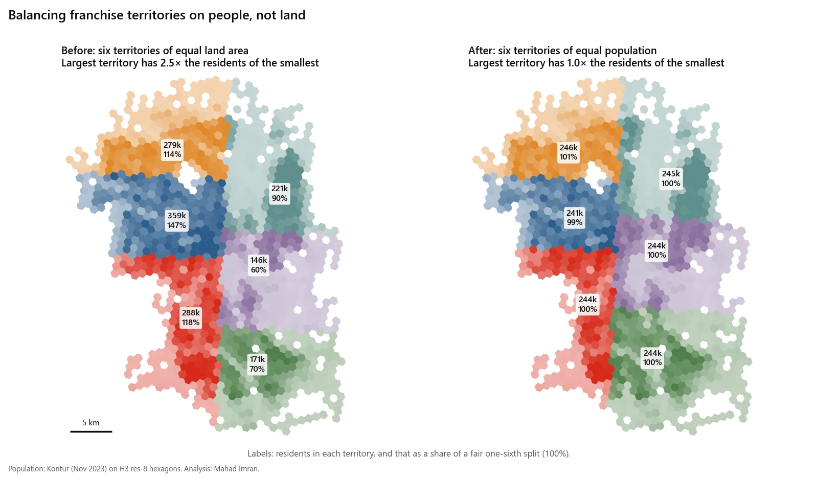
The same six-territory split, balanced on land and then on residents. Labels show residents and their share of a fair one-sixth.
Which territory boundaries cause disputes?
| Boundary type | Why it is tempting | Why it causes disputes |
|---|---|---|
| Radius around the unit | Easy to write, easy to explain | Rings overlap between neighbours, ignore rivers and highways, and move if the unit relocates |
| US ZIP codes | Everyone knows their ZIP code; marketing lists use them | ZIP codes are assigned to delivery routes, not drawn as areas. Census ZCTAs approximate them, and not every valid ZIP code has a ZCTA. |
| Canadian forward sortation areas (FSAs) | First three characters of the postal code, familiar to customers | Statistics Canada's census FSA boundaries are a Statistics Canada product derived from postal codes reported on census questionnaires, and postal codes are created and retired over time |
| Counties, municipalities | Legally defined and stable | Very unequal in population; one county can need five territories and its neighbour none |
| Custom polygon on roads and natural features | Fits the market exactly | Needs a precise map and data file, or nobody can tell which side of the line a customer is on |
The pattern behind most disputes is a boundary defined by a label (a ZIP code, an FSA, "the north side of the city") rather than a geometry. Labels change meaning when the underlying geography changes. A geometry does not.
What a territory definition should contain
Whatever boundary type the lawyer and franchisor choose, the GIS deliverable for each territory should include:
- A boundary file (GeoPackage, shapefile or GeoJSON) with a stated coordinate system.
- A version and date, and the data release used: for example, "ACS 2020-2024 5-year estimates" or "2021 Census, dissemination areas".
- The count of households, population or target customers inside it, with the method used to apportion units the boundary cuts.
- A printed exhibit map at a scale where every boundary street can be read.
- If postal codes are used, the list of codes as of a stated date, so a later change to postal geography does not silently change the territory.
How do territory maps feed the FDD in the US?
In the US, the FTC Franchise Rule requires a Franchise Disclosure Document with 23 items. Item 12, at 16 CFR 436.5(l), covers territory. In summary, it requires the franchisor to disclose:
- Whether the franchise is for a specific location or one the franchisor must approve.
- Any minimum territory, for example a radius or an area with a specified population.
- When the franchisor will approve relocation or additional outlets, and any rights of first refusal.
- Whether the territory is exclusive. If it is not, the document must include the prescribed statement beginning "You will not receive an exclusive territory."
- For exclusive territories, whether keeping exclusivity depends on sales volume, market penetration or another contingency, and other circumstances that let the franchisor modify territorial rights. The rule's own example is a population increase that allows an additional franchise.
- Restrictions on the franchisor, and on the franchisee, selling into or out of the territory, including through other channels such as the internet.
- Whether the franchisor or an affiliate runs a similar business under a different trademark.
Several of these points are GIS questions in disguise. If a territory is defined by population, someone has to measure it, from a named dataset, at signing and again when a population trigger is tested. If the franchisor reserves the right to add a unit when population grows, the method for counting that growth should be written down before it is needed. The map and its documentation are the evidence when a franchisee asks whether a new unit is inside their territory.
How do Canadian provincial franchise laws treat territory?
Franchise disclosure in Canada is provincial. Seven provinces have franchise statutes:
| Province | Statute |
|---|---|
| Alberta | Franchises Act and Franchises Regulation |
| British Columbia | Franchises Act |
| Manitoba | The Franchises Act |
| New Brunswick | Franchises Act |
| Ontario | Arthur Wishart Act (Franchise Disclosure), 2000 |
| Prince Edward Island | Franchises Act |
| Saskatchewan | The Franchise Disclosure Act, SS 2024, c 13, in force June 30, 2026 |
The Canadian Franchise Association's list shows no franchise disclosure statute in the other provinces or the territories.
Each province prescribes the content of its disclosure document in its own regulations. Alberta's is a clear example of how territory shows up. Item 18 of Schedule 1 to the Franchises Regulation requires the franchisor to describe any exclusive territory granted, and to disclose its policy, if any, on how close to an existing franchisee's outlet it may establish another franchise, a franchisor outlet, other methods of distribution under its marks, or similar businesses under a different mark. It also asks whether keeping the territory depends on sales volume, market penetration or another contingency, and when the territory may be altered.
In practice, that means a Canadian territory map should answer the same questions as a US one, plus a proximity question: how close can the next unit go? A map that shows existing units, territory boundaries and the distance or drive time between them supports that disclosure directly.
Units and data also differ. Canadian territory documents usually measure in kilometres, use census dissemination areas and Canadian population counts, and use FSAs where US documents use ZIP codes. A cross-border system should not reuse US territory sizes in Canada without recounting households: the same number of households can sit in very different areas on each side of the border.
Where does GIS work stop and legal work start?
GIS work covers designing balanced territories, choosing and documenting data, drawing and versioning the boundaries, counting households and target customers, producing exhibit maps and files, and answering "is this address inside territory 14?" consistently for years.
Legal work covers whether a territory is exclusive, what rights are reserved, how the map is incorporated into the agreement, what happens when population or postal geography changes, and what each US state and Canadian province requires in the disclosure document. The wording of a territory grant is a franchise lawyer's job, not GIS advice. Nothing in this article is legal advice. The best results come from the two working together: the lawyer decides what the territory means, and the map makes sure it means one thing.
When is formal territory mapping the wrong approach?
- When the franchise grants no territory. If the agreement grants only a site and the FDD says so, detailed territory design adds cost without protection. A map of existing units and their trade areas is still useful for planning.
- When the business is mainly online or delivery-led. Territory lines matter less than channel rules, which are contract terms.
- When there are too few units to balance. Two franchisees in a small city can agree a dividing road. Formal balancing is for systems selling many territories on the same terms.
- When the data are too coarse. In rural areas a single block group or dissemination area can be larger than a sensible territory. Balancing then needs smaller census units or address data, or the tolerance has to widen.
What are the limitations of the Calgary example?
The Calgary example balances modelled population from a 2023 grid, clipped to city limits, with straight cuts. A real territory plan would balance households or the target segment from census data, follow streets and rivers, check drive times to likely sites, and account for units already open. The point it makes holds regardless: equal area produced markets that differed by a factor of 2.47, and equal population brought that to 1.02.
Territory design is one part of planning a franchise network. Choosing and forecasting the sites inside each territory is covered in retail and franchise site selection with GIS.
If you need franchise territories designed, balanced or audited, email me at mahad.imran29@gmail.com.