Pakistan spans three UTM zones: 41N (60°E to 66°E), 42N (66°E to 72°E) and 43N (72°E to 78°E). On the WGS 84 datum their EPSG codes are 32641, 32642 and 32643. Karachi, Quetta, Peshawar and Multan fall in 42N, Lahore, Islamabad, Faisalabad and Gilgit in 43N, and Gwadar in 41N. About 54% of the country's area is in zone 42N.
This article lists the zone and EPSG code for each major city, shows how much error the wrong zone introduces, explains the legacy Kalianpur datums still found in Pakistani data, and gives the CRS to use for national analysis, with code for Python, PostGIS and QGIS.
Which UTM zone is Pakistan in?
Pakistan sits across three of the 6-degree UTM zones, split at the 66°E and 72°E meridians. I measured the share of the country in each zone by clipping Natural Earth's 10m country boundary (about 873,000 km², including Gilgit-Baltistan and Azad Jammu and Kashmir) at each zone edge and computing geodesic areas with pyproj.
| UTM zone | Longitudes | Central meridian | EPSG (WGS 84) | Share of Pakistan's area | Main cities |
|---|---|---|---|---|---|
| 41N | 60°E to 66°E | 63°E | 32641 | 20% | Gwadar, Turbat, Panjgur |
| 42N | 66°E to 72°E | 69°E | 32642 | 54% | Karachi, Hyderabad, Quetta, Sukkur, Multan, Bahawalpur, Peshawar |
| 43N | 72°E to 78°E | 75°E | 32643 | 26% | Lahore, Islamabad, Rawalpindi, Faisalabad, Gujranwala, Sialkot, Gilgit |
Pakistan's official map also includes the rest of Jammu and Kashmir, which reaches 79.6°E. That part crosses 78°E into zone 44N (EPSG:32644), and the outline in the figure below follows that map.
The 72°E boundary is the one that matters most in practice. It runs through Punjab, between Multan and Faisalabad, and through Khyber Pakhtunkhwa just east of Peshawar. Any project covering Punjab, or linking Peshawar with Islamabad, straddles two zones.
Which zone is each major city in?
Each city's zone follows from its longitude: zone = floor((longitude + 180) / 6) + 1. I used approximate city-centre coordinates and calculated the UTM scale factor at each one with pyproj, in its own zone and in the neighbouring zone, to show what picking the wrong zone costs.
| City | Longitude | UTM zone | EPSG | Scale error in own zone | Scale error in neighbouring zone |
|---|---|---|---|---|---|
| Gwadar | 62.32°E | 41N | 32641 | −34 cm per km | +5.22 m per km (42N) |
| Karachi | 67.01°E | 42N | 32642 | +9.9 cm per km | +1.63 m per km (41N) |
| Quetta | 67.00°E | 42N | 32642 | +5.8 cm per km | +1.43 m per km (41N) |
| Multan | 71.47°E | 42N | 32642 | +30 cm per km | +1.03 m per km (43N) |
| Peshawar | 71.58°E | 42N | 32642 | +30 cm per km | +83 cm per km (43N) |
| Islamabad | 73.05°E | 43N | 32643 | +0.3 cm per km | +1.34 m per km (42N) |
| Faisalabad | 73.08°E | 43N | 32643 | +1.1 cm per km | +1.46 m per km (42N) |
| Lahore | 74.34°E | 43N | 32643 | −35 cm per km | +2.77 m per km (42N) |
| Gilgit | 74.31°E | 43N | 32643 | −35 cm per km | +2.43 m per km (42N) |
Multan and Peshawar are the edge cases: both lie within half a degree of 72°E, so 42N and 43N are both tolerable there. Lahore is the city most exposed to a zone mix-up: a Punjab-wide dataset built in 42N carries nearly 3 metres per kilometre of scale error there.
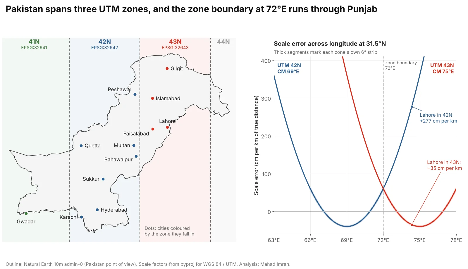
UTM scale error grows with the square of the distance from the central meridian. Lahore sits 0.7° from 43N's central meridian and 5.3° from 42N's.
How much error does the wrong UTM zone introduce?
The error depends on how far the data sits from the zone's central meridian. UTM uses a transverse Mercator projection with a scale factor of 0.9996 on the central meridian, so distances there are 40 cm per km too short. The scale factor rises to exactly 1 about 180 km either side and keeps growing beyond that.
For Lahore the numbers are:
- In 43N (correct): scale factor 0.99965. A 10 km road measures 9,996.5 m.
- In 42N (wrong): scale factor 1.00277. The same road measures 10,027.7 m, and areas come out 0.56% too large.
That sounds small until it accumulates. A 50 km canal reach in Lahore district measured in 42N is 139 m too long. A parcel layer for the district overstates every plot by over half a percent. Errors of this size are invisible on a map and obvious as soon as the numbers are checked against a survey.
Projects that straddle the boundary should pick one zone and use it for everything. For Punjab as a whole, zone 43N keeps the scale error under 0.34% everywhere in the province, with the worst values at its western edge near Rajanpur. I go through the same choice for satellite mosaics in mosaicking Sentinel-2 tiles across UTM zones.
What are the Kalianpur 1937, 1962 and 1975 datums?
Kalianpur is the family of datums of the old Indian survey, named after its origin station in central India and computed on versions of the Everest ellipsoid. Pakistani data from before GPS, and much that was digitised from it, uses one of them. The definitions below come from the EPSG dataset (version 12.029, read through pyproj).
| Datum | EPSG (geographic) | Ellipsoid | Semi-major axis | Area of use |
|---|---|---|---|---|
| Kalianpur 1880 | 4243 | Everest (1830 Definition) | 6,377,299.366 m | Pakistan, India, Bangladesh, Myanmar |
| Kalianpur 1937 | 4144 | Everest 1830 (1937 Adjustment) | 6,377,276.345 m | Pakistan, India, Bangladesh, Myanmar |
| Kalianpur 1962 | 4145 | Everest 1830 (1962 Definition) | 6,377,301.243 m | Pakistan |
| Kalianpur 1975 | 4146 | Everest 1830 (1975 Definition) | 6,377,299.151 m | India |
| WGS 84 | 4326 | WGS 84 | 6,378,137.000 m | World |
Kalianpur 1962 is the Pakistani one. The EPSG dataset defines these projected systems on it:
| Projected CRS | EPSG | Projection | Area of use in Pakistan |
|---|---|---|---|
| Kalianpur 1962 / UTM zone 41N | 24311 | Transverse Mercator, 63°E | West of 66°E |
| Kalianpur 1962 / UTM zone 42N | 24312 | Transverse Mercator, 69°E | 66°E to 72°E |
| Kalianpur 1962 / UTM zone 43N | 24313 | Transverse Mercator, 75°E | East of 72°E |
| Kalianpur 1962 / India zone I | 24376 | Lambert conformal conic, 32°30'N, 68°E | 28°N to 35°35'N |
| Kalianpur 1962 / India zone IIa | 24377 | Lambert conformal conic, 26°N, 74°E | South of 28°N |
The two Lambert "India zone" grids are the Indian Grid system inherited from the Survey of India; the EPSG dataset records these metric versions for Pakistan's use after metrication. North of 35°35'N the old grid continued as India zone 0 (EPSG:24370), defined on Kalianpur 1880 in Indian yards. If a shapefile from a government department has coordinates in the millions with no projection file, one of these grids is a likely candidate.
How big is the shift from Kalianpur 1962 to WGS 84?
The same point moves tens of metres on the ground, and its UTM coordinates change by about 260 to 285 metres because the two datums use different ellipsoids. The general EPSG transformation for onshore Pakistan is EPSG:1247, "Kalianpur 1962 to WGS 84 (1)", a geocentric translation of +283 m, +682 m and +231 m that EPSG attributes to the US Defense Mapping Agency. EPSG does not state its accuracy. Five more transformations (EPSG:15701 to 15703, 15494 and 9234) were derived for oil and gas licence areas in Sindh and the offshore Indus fan, with stated accuracies of 1 to 3 m.
I applied EPSG:1247 at each city with pyproj and measured the result two ways:
| City | Ground shift of the same point | Change in UTM coordinates (Kalianpur 1962 UTM vs WGS 84 UTM) |
|---|---|---|
| Quetta | 13 m | 261 m |
| Karachi | 39 m | 259 m |
| Multan | 53 m | 261 m |
| Gwadar | 76 m | 264 m |
| Islamabad | 85 m | 283 m |
| Lahore | 91 m | 282 m (97 m in easting, 264 m in northing) |
| Gilgit | 112 m | 285 m |
The second column is the one that bites. If Kalianpur 1962 / UTM 43N coordinates are loaded and labelled as WGS 84 / UTM 43N, every feature lands about 280 m from where it should be, mostly to the south (in zone 42N the figure is about 260 m). That is enough to put a school in the wrong union council or a well on the wrong side of a canal. A relabel looks harmless because the numbers are in the same range, and that is exactly why it goes unnoticed.
from pyproj import Transformer
from pyproj.transformer import TransformerGroup

# See every transformation PROJ knows for this pair, with area and accuracy
for t in TransformerGroup("EPSG:4145", "EPSG:4326").transformers:
    print(t.description, t.accuracy, t.area_of_use.name)

# Legacy Kalianpur 1962 / UTM 43N to WGS 84 / UTM 43N (uses EPSG:1247 onshore)
t = Transformer.from_crs("EPSG:24313", "EPSG:32643", always_xy=True)
x, y = t.transform(437453.5, 3490482.8)   # a point in Lahore
print(round(x), round(y))                  # 437356, 3490747
If you work inside one of the oil and gas licence areas, pick the matching local transformation explicitly. Otherwise EPSG:1247 is the reasonable default, with the caveat that its accuracy is unstated and likely to be several metres.
What coordinate system should you use for all of Pakistan?
For national statistics, use an equal-area projection, or skip projection and compute on the ellipsoid. A country 16 degrees wide does not fit any single UTM zone. I computed Pakistan's area (Natural Earth boundary, densified to 0.05° segments) in several CRSs and compared each with the geodesic area of 872,939 km².
| CRS | Area of Pakistan | Error | Notes |
|---|---|---|---|
| Geodesic on WGS 84 | 872,939 km² | none | Reference value |
| Custom Albers equal-area (below) | 872,939 km² | 0.00% | Length error within ±0.34% |
| WGS 84 / UTM 42N | 874,738 km² | +0.21% | Errors partly cancel; up to +1.3% locally at the edges |
| Kalianpur 1962 / India zone I | 875,489 km² | +0.29% | Conformal, so area is not preserved |
| WGS 84 / UTM 43N | 881,857 km² | +1.02% | Western Balochistan is 12° from the central meridian |
| Web Mercator (EPSG:3857) | 1,171,921 km² | +34.25% | Display only |
EPSG has no equal-area CRS made for Pakistan, so define one. I used the usual one-sixth rule for standard parallels across Pakistan's 23.7°N to 37.1°N span, rounded:
+proj=aea +lat_0=30 +lon_0=69 +lat_1=26 +lat_2=35 +x_0=0 +y_0=0 +datum=WGS84 +units=m +no_defs
Over Pakistan this Albers projection preserves area exactly, keeps distances within 0.34% (scale factors 0.9966 to 1.0034) and distorts angles by no more than 0.4°. It is the right CRS for district areas, densities per square kilometre and national gridded statistics. For distances and buffers, keep using the local UTM zone or compute geodesically.
Web Mercator's 34% inflation of Pakistan's area is the same effect described in Web Mercator area and distance errors. You can see it directly by dragging Pakistan north or south on the True Size Map.
How do you pick and convert coordinate systems in Python, PostGIS and QGIS?
Python (GeoPandas and pyproj). estimate_utm_crs() picks the zone from the centre of the data's bounds. It returned EPSG:32643 for Lahore and EPSG:32642 for Peshawar and Karachi. For data straddling 72°E it will pick whichever side the centre falls on, so check the answer.
import geopandas as gpd

gdf = gpd.read_file("schools.gpkg").to_crs(4326)

# Local work: one UTM zone for the whole project
utm = gdf.estimate_utm_crs()          # e.g. EPSG:32643 for Lahore
local = gdf.to_crs(utm)
local["buffer_2km"] = local.buffer(2000)

# National statistics: custom Albers equal-area
PAK_AEA = ("+proj=aea +lat_0=30 +lon_0=69 +lat_1=26 +lat_2=35 "
           "+x_0=0 +y_0=0 +datum=WGS84 +units=m +no_defs")
districts = gpd.read_file("districts.gpkg").to_crs(PAK_AEA)
districts["area_km2"] = districts.area / 1e6
PostGIS. Add the custom Albers to spatial_ref_sys once, then use it like any other SRID. Use the geography type when you only need a geodesic number.
INSERT INTO spatial_ref_sys (srid, auth_name, auth_srid, proj4text)
VALUES (990001, 'custom', 990001,
  '+proj=aea +lat_0=30 +lon_0=69 +lat_1=26 +lat_2=35 +x_0=0 +y_0=0 +datum=WGS84 +units=m +no_defs');

-- Equal-area district areas
SELECT name, ST_Area(ST_Transform(geom, 990001)) / 1e6 AS area_km2 FROM districts;

-- Geodesic area, no projection needed
SELECT name, ST_Area(geom::geography) / 1e6 AS area_km2 FROM districts;  -- geom in 4326

-- Legacy Kalianpur 1962 / UTM 42N data loaded without an SRID
UPDATE canals SET geom = ST_Transform(ST_SetSRID(geom, 24312), 32642);
QGIS. Set the project CRS to the zone of your area (Project, Properties, CRS, search "32643"). When a layer on Kalianpur 1962 is added, QGIS can ask which datum transformation to use, listing the candidates with their areas and accuracies (turn on "Ask for datum transformation if several are available" under Settings, Options, Transformations). Choose "Kalianpur 1962 to WGS 84 (1)" unless you are inside one of the licence areas. Add the Albers string as a custom CRS under Settings, Custom Projections. For measurement, set the ellipsoid under Project, Properties, General so that $area and $length return ellipsoidal values.
For city-scale work in the capital, such as the walking-distance study in How far is the nearest school or college in Islamabad?, EPSG:32643 is the natural working CRS: Islamabad sits a degree inside zone 43N, where the scale error is 3 mm per km.
What should you take from this?
Use EPSG:32642 for Sindh, most of Balochistan, south and west Punjab and Khyber Pakhtunkhwa, EPSG:32643 for Islamabad, Lahore, north and east Punjab, Azad Jammu and Kashmir and Gilgit-Baltistan, and EPSG:32641 only for western Balochistan. For anything province-wide or national, measure in an equal-area projection or on the ellipsoid. And treat any legacy dataset with coordinates in metres and no clear datum as a possible Kalianpur 1962 file, because a missing datum transformation moves everything about 280 metres while looking entirely plausible.
If you have Pakistani GIS data in an unknown or legacy coordinate system that needs sorting out, or a national analysis that needs to be set up in the right CRS from the start, email me at mahad.imran29@gmail.com.