Population, schools, and the walking network fetched live from Kontur/HDX, Overture Maps, and OpenStreetMap on 2026-06-09.
1. The question
For every place where people live in Islamabad, how far do they actually have to walk to reach the nearest school or college? Not the crow-flies distance, but the real route along streets and paths.
"School" here means schools and colleges (in Pakistan a college is usually an intermediate or degree college serving school-age students). Universities are excluded.
2. Headline numbers
| Metric | Value |
|---|---|
| Population analysed | 2,494,832 (Kontur/HDX modeled grid, 1,153 hexagons) |
| Schools & colleges located | 1,131 (universities excluded) |
| People per institution | ~2,200 |
| Median walk to nearest institution | 1.01 km (about a 12-minute walk) |
| Mean walk | 1.55 km |
| Within a 1 km walk | 49.3% |
| Within a 2 km walk | 73.9% |
| Beyond a 2 km walk | 26.1% (651,000 people) |
| Beyond a 3 km walk | 13.7% (342,000 people) |
| Furthest populated cell | 15.1 km by walking route |
The one-line finding: Only about three in four residents live within 2 km of a school or college. Roughly 651,000 people, mostly in the rural and peri-urban edges of the Capital Territory, have to travel further than that.
3. The maps
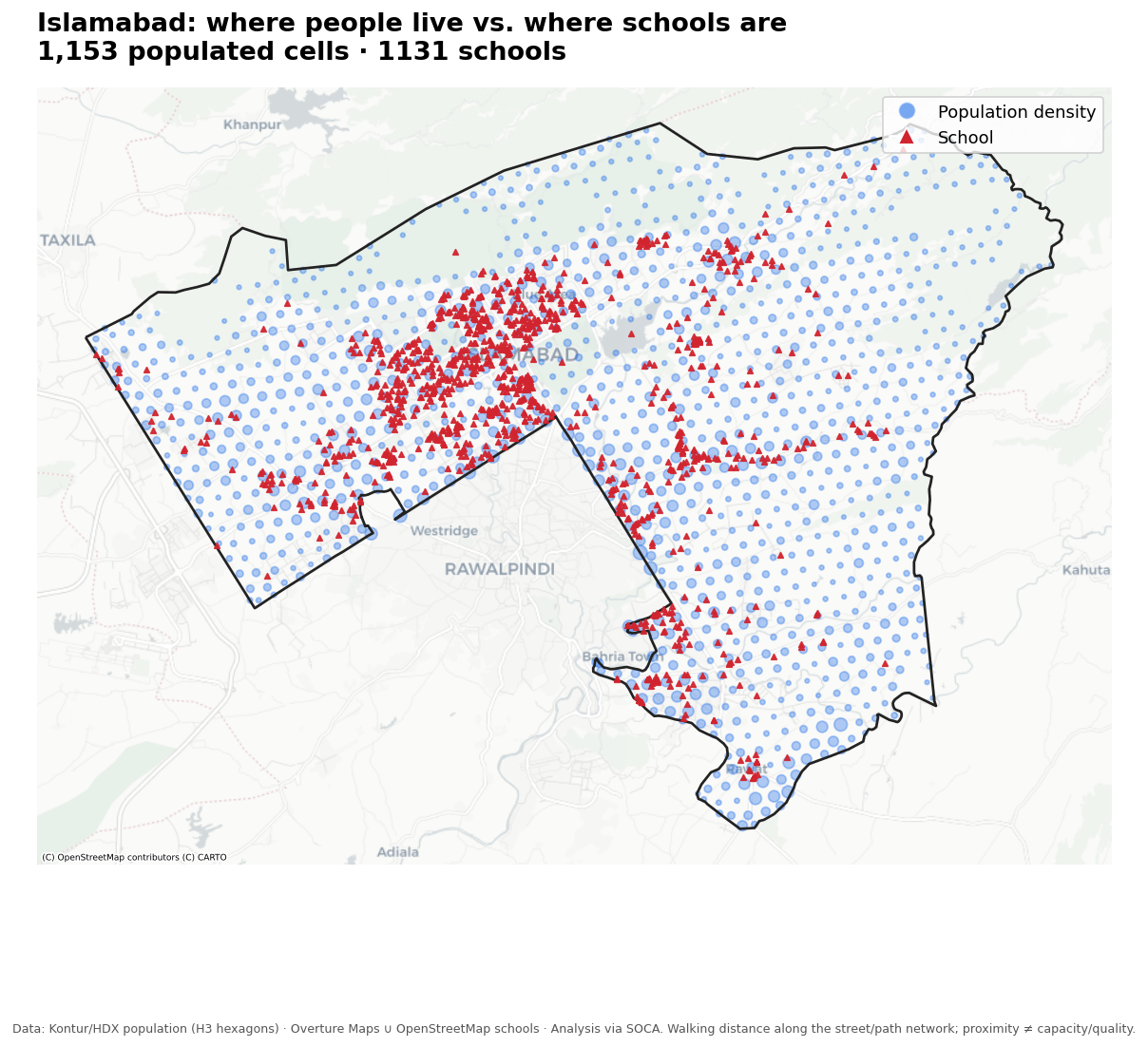
Figure 1: Supply vs. demand. Institutions (red) track the planned sector grid; population (blue) spills well beyond it.
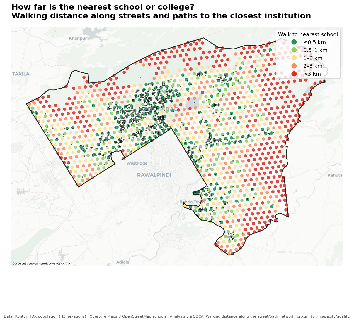
Figure 2: The access map. Each cell coloured by walking distance to its nearest school or college.

Figure 3: Coverage curve. Share of people within a 0.5 / 1 / 2 / 3 / 5 km walk.
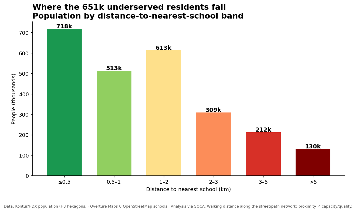
Figure 4: Population by walking-distance band.
4. How the network distance was computed
- Walking network: a pedestrian street and path network for the entire 959 km² Capital Territory, fetched from OpenStreetMap via OSMnx: 55,068 nodes and 146,092 edges.
- Snapping: every population hexagon centroid and every institution was snapped to its nearest network node. The gap from each home cell to its node was added back so that homes set away from a mapped road are not flattered.
- One multi-source shortest path: all 1,131 institution nodes were treated as sources in a single Dijkstra pass over the network. That returns the shortest walking distance to the nearest institution for every node at once, which is why the whole computation runs in seconds rather than routing millions of pairs.
- Result: every populated cell was reachable (no isolated cells). Islamabad's large sector superblocks force pedestrians along the road hierarchy, which is why walking distances can be substantially longer than a direct path would suggest.
5. A tale of two cities
Islamabad is a planned city of lettered and numbered sectors wrapped inside a much larger, partly rural Capital Territory. The split is clear on the map. The sectors are well covered, with short walks to school. The periphery, including the rural union councils and the land rising into the Margalla Hills, carries almost all of the long journeys. Those areas hold a smaller share of the people but a large share of the distance, which is why a quarter of the population still ends up beyond a 2 km walk.
Islamabad has about one school or college for every 2,200 residents, which is a healthy ratio. The institutions sit where the city was planned, and the population has grown past those lines. This is a question of where the schools are, more than how many there are.
6. Population by walking-distance band
About 718,000 people live within a 500-metre walk of a school or college. Another 513,000 are between 500 metres and one kilometre, and 613,000 between one and two kilometres. After that the journeys get long: 309,000 people walk two to three kilometres, 212,000 walk three to five, and roughly 130,000 walk more than five kilometres to reach the nearest institution. Those last three groups make up the 651,000 residents outside a reasonable walking distance.
7. Does the school definition change the result?
No. The table below runs the analysis three ways. The conclusion holds across all of them.
| Definition | Institutions | Within 2 km walk | People beyond 2 km |
|---|---|---|---|
| Schools only, no colleges | 728 | 69.4% | 763,000 |
| Schools and colleges (used here) | 1,131 | 73.9% | 651,000 |
| All education, including universities | 1,256 | 74.5% | 636,000 |
8. Limitations
- Network coverage may slightly overstate the walk. OpenStreetMap maps named roads well but misses some informal footpaths and shortcuts, especially in dense and informal areas.
- Being close is not the same as having a place. This measures whether an institution exists within reach. It says nothing about seats, grade levels, gender, or quality.
- The school map is incomplete. Small private academies, religious schools, and informal setups are under-recorded; 1,131 is a lower bound.
- Population is modeled, not counted. The Kontur grid is a strong estimate and its total matches the 2023 census closely, but any single cell carries error.
9. Where this goes next
The same network layer can feed an optimisation model. Given the 651,000 people beyond a 2 km walk, where would a handful of new schools cover the most people for the least cost? A Maximal Covering solver answers exactly that and turns this diagnosis into a ranked list of sites.